Syracuse Weather Alert: Up to 8 Inches of Lake-Effect Snow Expected Today
Residents across Syracuse and Central New York are bracing for a blast of winter weather today, as forecasters warn of intense lake-effect snow capable of dropping up to eight inches in certain areas. Roads, sidewalks, and visibility are all expected to be affected throughout the day.
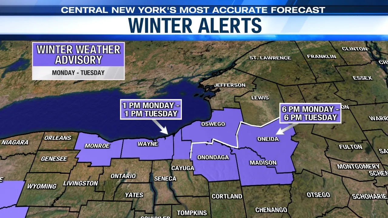
Cold Air and Lake Ontario Combine for Heavy Snow
A surge of cold Arctic air moving across the relatively warm waters of Lake Ontario is creating ideal conditions for heavy, localized snow bands. Meteorologists say these lake-effect snow showers will be most intense through the late morning and early afternoon before gradually tapering off by evening.
While most neighborhoods in Onondaga and Madison counties can expect 3 to 6 inches, isolated zones directly under persistent snow bands could see as much as 7 to 8 inches of accumulation.
Travel Conditions and Timing
The heaviest snow is expected during the late-morning commute, with gusty northwest winds creating blowing and drifting snow. Motorists are urged to use caution, as visibility could drop to less than a quarter mile in some spots.
Major routes such as Interstate 81, Interstate 690, and portions of the New York State Thruway (I-90) may experience slick conditions and periodic whiteouts.
Authorities advise travelers to reduce speed, keep headlights on, and maintain safe following distances.
Safety Tips for Residents
-
Avoid unnecessary travel during peak snowfall.
-
If driving is unavoidable, carry winter essentials like blankets, flashlights, and extra warm clothing.
-
Allow extra time for commuting and be prepared for sudden changes in road conditions.
-
Keep sidewalks and driveways clear to prevent ice buildup.
-
Check on elderly neighbors or anyone who may need help during severe weather.
Community Preparedness
Public works crews across the Syracuse area began salting and pre-treating major roads early this morning. Snowplows will remain active throughout the day, focusing on key intersections, bridges, and bus routes.
Local schools and businesses are monitoring the storm closely, though no widespread closures had been reported as of early morning.
A Typical Start to a Syracuse Winter
For residents of Syracuse—one of the snowiest cities in the United States—lake-effect events are nothing new. Still, today’s storm serves as an early reminder of how quickly winter can return to Central New York.
The National Weather Service continues to caution residents that lake-effect snow is unpredictable, and accumulations can vary dramatically even across short distances. Just a few miles can mean the difference between flurries and near-whiteout conditions.
Snow showers are expected to diminish by late evening as winds shift and the lake-effect bands drift northward.
Temperatures will remain below freezing overnight, leading to icy patches and continued slick travel into Wednesday morning.
Forecasters predict that the region could see another round of light lake-effect snow later this week as cold air lingers. Residents are urged to stay weather-aware and ready for quick changes in conditions.

Pulkeet Gupta is a dedicated content writer specializing in the field of education and entertainment niche. With a passion for learning and a keen interest in sharing knowledge, Pulkeet has established himself as a prominent figure in the education and entertainment writing community.