Northern Michigan Weather Alert: On-and-Off Snow Chances Expected to Continue Next Week
Northern Michigan residents should be ready for a stretch of unsettled winter weather next week, as periodic snow chances remain in the forecast. While no major storm is expected at this time, the region will continue to see intermittent snowfall, especially in areas influenced by lake-effect activity.
Weather patterns across the Great Lakes are favoring repeated cold air surges, allowing snow showers to develop and redevelop over several days.
Snowfall Arrives in Intervals
Rather than one long-lasting system, snow will arrive in shorter rounds, with occasional breaks in between. Light to moderate snow is expected at times early in the week, followed by additional chances later as colder air moves back into the region.
Some areas may see little accumulation during one round, only to receive a fresh coating during the next. This stop-and-go pattern can make road conditions change quickly.
Lake-Effect Snow Remains a Factor
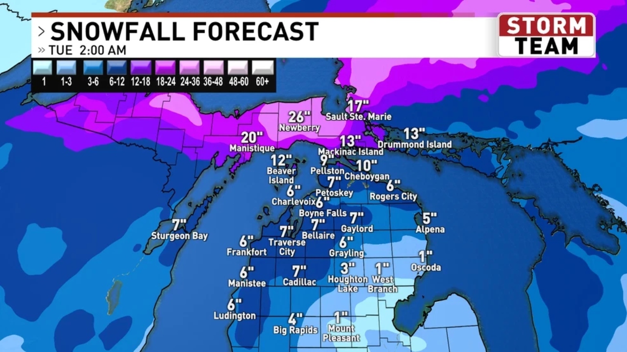
Lake-effect snow will continue to play a role, particularly downwind of Lake Michigan and Lake Huron. When winds align just right, localized bands can produce heavier snowfall over short periods, leading to uneven accumulation totals across nearby communities.
Snow-belt locations may experience more frequent snowfall, while inland areas see lighter and less persistent activity.
Travel Conditions May Vary Daily
With snow chances spread out over several days, drivers should expect changing travel conditions. Some mornings may begin dry, while afternoon or evening snow showers could quickly reduce visibility and create slick roads.
Temperatures staying below freezing will also allow snow and ice to linger, especially on untreated roads and shaded areas.
Cold Temperatures Continue
Daytime highs across northern Michigan are expected to remain below seasonal averages, generally ranging from the teens to low 20s. Overnight lows will dip well below freezing, keeping winter firmly in place.
Cold air moving across the lakes may also bring periods of gusty winds, increasing wind chill values and enhancing snowfall in lake-effect zones.
What Residents Should Do
Residents are encouraged to:
-
Check daily forecasts before heading out
-
Allow extra travel time during snow showers
-
Keep vehicles winter-ready with emergency supplies
-
Use caution on bridges and secondary roads
Even light snowfall can create hazardous conditions when temperatures stay cold.
Outlook for the Week Ahead
Northern Michigan will remain locked in a wintry pattern through next week, with snow chances coming and going and cold air firmly in place. While widespread heavy snow is not currently expected, the repeated rounds of snowfall mean residents should stay prepared for changing conditions and winter travel challenges.

Pulkeet Gupta is a dedicated content writer specializing in the field of education and entertainment niche. With a passion for learning and a keen interest in sharing knowledge, Pulkeet has established himself as a prominent figure in the education and entertainment writing community.