Midwest Weather Alert: Strong Clipper System to Bring Wind and Blowing Snow Across Minnesota, Wisconsin, and Michigan
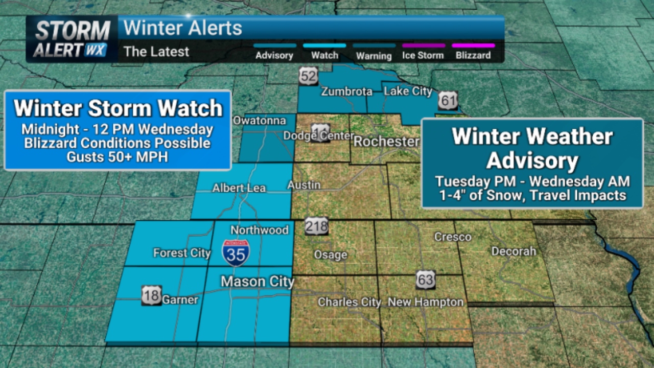
A fast-moving winter storm system is set to sweep across the Upper Midwest, bringing strong winds, blowing snow, and hazardous travel conditions to parts of Minnesota, Wisconsin, and Michigan between December 17 and December 18. Forecasters warn that even modest snowfall totals could create dangerous conditions due to powerful gusts and rapidly changing visibility.
What Is Driving This Winter Weather Event?
The approaching system is known as a clipper, a type of winter storm that moves quickly from northwest to southeast. While clippers typically do not produce heavy snow totals, they are notorious for strong winds, sudden temperature drops, and widespread blowing snow — all of which can significantly impact travel.
As this system pushes through the region, colder Arctic air will follow close behind, reinforcing winter conditions and making roads icy and slick.
Areas Most Likely to Be Affected
The strongest impacts are expected across:
-
Northern and central Minnesota, where winds could gust over 40 mph
-
Northern Wisconsin, especially open rural areas prone to drifting snow
-
Upper Michigan, including exposed roadways and lake-effect-enhanced areas
Snowfall totals may range from 1 to 4 inches, but whiteout conditions are possible in open areas due to intense wind gusts.
Travel Impacts and Safety Concerns
Even light snowfall combined with strong winds can quickly reduce visibility to near zero. Drivers should prepare for:
-
Sudden whiteouts on highways
-
Snow-covered and icy roads
-
Dangerous conditions on bridges and overpasses
-
Delays or cancellations for flights and ground transportation
Officials urge residents to limit travel during peak storm hours, particularly overnight and early morning when road crews may struggle to keep up with blowing snow.
Wind Chill and Temperature Drop
Behind the storm, temperatures are expected to plunge, with wind chills dropping into the single digits and below zero across parts of the region. Prolonged exposure could pose risks for those working outdoors, including frostbite and hypothermia.
Residents should dress in layers, cover exposed skin, and ensure pets and vulnerable individuals are protected from the cold.
How to Prepare Before the Storm Arrives
To stay safe during this Midwest winter weather event:
-
Check road conditions before traveling
-
Keep emergency supplies in vehicles, including blankets and flashlights
-
Secure outdoor items that strong winds could blow
-
Monitor local weather updates for changing conditions
Even short trips could become dangerous if visibility drops suddenly.
Looking Ahead
Conditions are expected to gradually improve late on December 18 as the clipper exits the region. However, lingering cold air and drifting snow may continue to cause travel issues in some areas.
Winter weather remains active across the Midwest, and this storm serves as another reminder that fast-moving systems can still pack a serious punch, especially when wind and cold combine.

Pulkeet Gupta is a dedicated content writer specializing in the field of education and entertainment niche. With a passion for learning and a keen interest in sharing knowledge, Pulkeet has established himself as a prominent figure in the education and entertainment writing community.